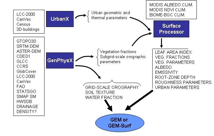
This methodology is currently being used to produce a consistent set of surface characteristics for regions with urban areas (including buildings and roads) and / or natural areas (including bare soil and vegetation-covered surfaces). In the Surface Processor, the GenPhysX module read the appropriate databases and specify the orographic parameters (grid- and subgrid-scale), the water fractional coverage, the soil texture, and the fractional coverage for each type of vegetation land cover.
The GenPhysX module (Zadra et al., 2008) processes the databases for these specific aspects and perform spatial averaging, counting, as well as calculations for orography (mean height, slope, aspect, and subgrid-scale parameters). Some of the parameters are directly used by GEM and GEM-Surf, such as the soil texture, grid-scale orography, and water fractional coverage. Other GenPhysX outputs are provided to the Surface Pre-Processor (subgrid-scale orographic parameters, vegetation fractions). Together with other inputs, i.e., climatologies for albedo, NDVI, and LAI, the Surface Pre-Processor produces the rest of the surface parameters over land, including the LAI, vegetational fractional coverage, vegetation paramters, albedo, root-zone depth.
The UrbanX module, on the other hand, reads another set of databases to calculate the geometric parameters of city areas and uses a series of look-up tables to specify the thermal parameters for the urban areas. The list of surface parameters to be initialized for TEB (urban component) is the following:
| NATF | fraction of natural surface |
| BLDF | fraction of building |
| PAVF | fraction of paved area |
| BLDH | building height |
| Z0RF | roof aerodynamic roughness length |
| Z0RD | road aerodynamic roughness length |
| ALRF | albedo roof |
| ALRD | albedo road |
| ALWL | albedo wall |
| EMRF | emissivity roof |
| EMRD | emissivity road |
| EMWL | emissivity wall |
| HCRF | (ip1=1199) heat capacity layer 1 roof |
| HCRD | (ip1=1199) heat capacity layer 1 road |
| HCWL | (ip1=1199) heat capacity layer 1 wall |
| HCRF | (ip1=1198) heat capacity layer 2 roof |
| HCRD | (ip1=1198) heat capacity layer 2 road |
| HCWL | (ip1=1198) heat capacity layer 2 wall |
| HCRF | (ip1=1197) heat capacity layer 3 roof |
| HCRD | (ip1=1198) heat capacity layer 3 road |
| HCWL | (ip1=1197) heat capacity layer 3 wall |
| TCRF | (ip1=1199) thermal conductivity layer1 roof |
| TCRD | (ip1=1199) thermal conductivity layer1 road |
| TCWL | (ip1=1199) thermal conductivity layer1 wall |
| TCRF | (ip1=1198) thermal conductivity layer2 roof |
| TCRD | (ip1=1198) thermal conductivity layer2 road |
| TCWL | (ip1=1198) thermal conductivity layer2 wall |
| TCRF | (ip1=1197) thermal conductivity layer3 roof |
| TCRD | (ip1=1197) thermal conductivity layer3 road |
| TCWL | (ip1=1197) thermal conductivity layer3 wall |
| DPRF | (ip1=1199) heat capacity layer 1 roof |
| DPRD | (ip1=1199) heat capacity layer 1 road |
| DPWL | (ip1=1199) thickness layer 1 wall |
| DPRF | (ip1=1198) thickness layer 2 roof |
| DPRD | (ip1=1198) thickness layer 2 road |
| DPWL | (ip1=1198) thickness layer 2 wall |
| DPRF | (ip1=1197) thickness layer 3 roof |
| DPRD | (ip1=1197) thickness layer 3 road |
| DPWL | (ip1=1197) thickness layer 3 wall |
| QHTR | sensible anthropogenic heat flux generated by traffic road |
| QETR | latent anthropogenic heat flux generated by traffic road |
| QHIN | sensible anthropogenic heat flux generated by industry roof |
| QEIN | latent anthropogenic heat flux generated by industry roof |
| WHOR | S_wall/S_horizontal canopy |
| Z0TW | canopy aerodynamic roughness length canopy |
Bélair, S., 2012: Algorithms for land surface characteristics in GEM. Internal document. Link to PDF
Bélair, S., 2012: Algorithms for land surface characteristics in the high-resolution external land surface modeling system GEM-Surf. Internal document. Link to PDF
Lemonsu, A., A. Leroux, S. Bélair, S. Trudel, and J. Mailhot, 2008: A general methodology of urban land cover type classification for atmospheric modeling. Internal document. Link to PDF
Leroux, A., J.-P. Gauthier, A. Lemonsu, S. Bélair, and J. Mailhot, 2009: Automated urban land used and land cover classification for mesoscale atmospheric modeling over Canadian cities. Geomatica, 63, 393-406. Link to PDF
Zadra, A., J.-P. Gauthier, and A. Leroux, 2008: GenPhysX a user's guide to input/output and methods. Internal document. Link to PDF